
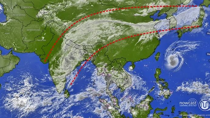
Sky Highway: INSAT-3DS Captures Cloud Band Linking India to Japan
Space observation entered a striking new phase when high-resolution imagery from the Indian Space Research Organisation’s (ISRO) INSAT-3DS meteorological satellite captured an exceptional planetary event: a continuous, thousands-of-kilometers-long “cloud highway” sweeping directly across the Asian continent. Originating over the moisture-rich waters of the Bay of Bengal and central-eastern India, this dense plume of atmospheric moisture arc-traversed across the Himalayas, traversed mainland China and the Korean Peninsula, and stretched all the way to the Japanese archipelago.
What makes this visual snapshot remarkable is the sheer scale and uninterrupted continuity of the cloud band across varying climate zones. Observed through the satellite’s advanced 6-channel Imager and 19-channel Sounder, the imagery shows deep convective thunderstorm systems brewing in the Indian subcontinent feeding directly into upper-level atmospheric channels. These channels act as massive conveyor belts, propelling humid air masses northeastward at high velocities and forging a visual bridge between tropical South Asia and the mid-latitude environments of East Asia.
Meteorologists explain that while the phenomenon appears as a singular entity from geostationary orbit, it is driven by complex thermodynamic interactions. Strong monsoonal upwelling over India injects millions of tons of water vapor into the middle and upper troposphere. Once elevated, this moisture is intercepted by fast-moving subtropical jet streams that flow west-to-east across Eurasia. The high-altitude winds stretch the cloud masses into a narrow, continuous ribbon, seamlessly merging local monsoonal weather fronts with mid-latitude storm systems thousands of miles away.
The capture of this transcontinental cloud highway demonstrates the vital role played by Ministry of Earth Sciences (MoES) operational platforms. By delivering continuous infrared and visible observations with reduced thermal interference, INSAT-3DS gives weather agencies like the India Meteorological Department (IMD) the ability to trace global atmospheric connections. This imagery provides valuable real-time data for refining numerical weather models, forecasting extreme rainfall events, and improving our understanding of how interconnected Earth’s regional climate systems truly are.