
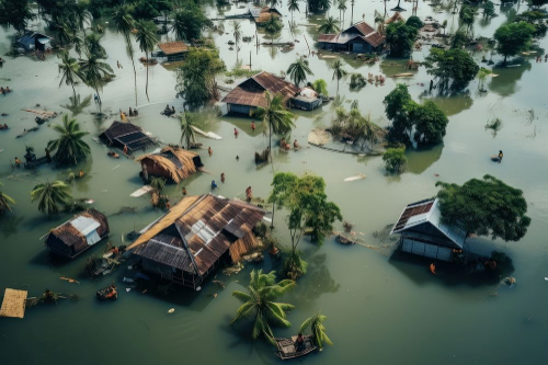
Flood in Sibsagar- A Hazard
By Dr. Neha Boruah
Flooding in Upper Assam has continued to worsen amid several days of incessant heavy rainfall, with the districts of Sivasagar and Charaideo emerging as the worst affected. Sivasagar district has been affected by continuous rainfall, leading to flooding in several parts. Water has entered residential areas, schools and government institutions. The strong currents of the Dikhow river have damaged embankments at multiple locations. According to the latest weather forecast, rainfall is expected to continue over the coming days, prompting concerns that the flood situation in Upper Assam may worsen further. Floodwater rapidly reached critical levels on Sunday (July 19) and has been spreading since then; the total population affected is now estimated at seven lakh across 856 villages in 12 districts. Around 58 lives have been lost in around a week, seven lakh people have been affected, and the government is yet to reach more than 50,000 people for relief.
The Assam government had initially attributed the flooding to a “cloudburst” in the neighbouring hill district of Mon in Nagaland on July 19. The Meteorological Centre Kohima, however, told The Indian Express that the area had not experienced a cloudburst, which the India Meteorological Department defines as rainfall exceeding 100 mm within one hour, but rather heavy rainfall of 137 mm over the course of eight to nine hours on that day. In general, experts agree that with climate change, high-intensity rainfall events of more than 50 mm or 100 mm in one day, which cause damage and floods, are becoming more frequent and will increase in the coming years.
Rescue and Relief Measures
Assam is facing a worsening flood situation; the Assam government is scaling up its emergency response across the affected districts. The State Disaster Response Force (SDRF), National Disaster Response Force (NDRF), district administrations and local volunteers have been deployed for rescue and relief operations. Boats are being used to evacuate stranded residents, while temporary relief camps have been established for displaced families. The state government has requested the Indian Army and the Indian Air Force to remain on standby for possible deployment if flood conditions worsen further, loss of life and property, and ensure the safety of affected residents.
Recommendations
- Study of the surrounding landscape can help to assess whether more detailed assessment and intervention should be considered.
- The flood hazard can change dramatically over short distances; the exact geographical location of the project should be checked against pre-existing flood hazard information.
- Detailed understanding of the risk posed to your asset by flooding. The level of guidance required will depend upon the level of hazard present, the vulnerability of the asset and local legislation that might apply.
- A high level of flood hazard; relocation to areas not prone to flooding is recommended where viable. This decision will need to be undertaken with the consideration of other hazards.
- Receive warning messages and be aware of what happens when a warning is triggered and ensure the warnings will be received in the facilities built and the people working or living there.
- Flood management measures, such as restoration of natural wetlands, removal of impermeable surfaces, or implementation of flood defences at the project site and in the upstream catchment.